
Wednesday, 30 November 2011
Wednesday, 2 November 2011
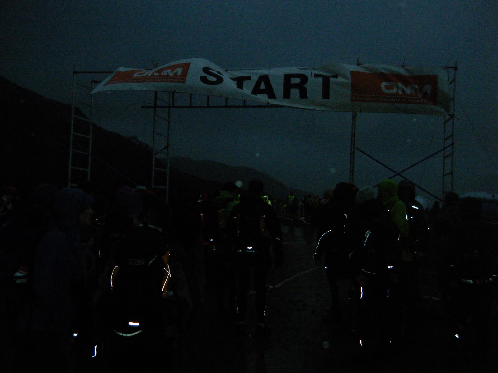
Gore Tex and Testosterone - OMM 2011
Warning: this could be a long one and there are going to be a lot of boring notes for my own benefit, so feel free to get a cup of tea and have a sit down, or just skip to the bottom to see how it all panned out.
Preamble
The title comes from a comment my partner run2thehills (or Ian) made on the Friday night as we had a quiet beer before an early night - never had so much technical clothing been seen in one place before, or so it seemed. I slept OK but the alarm came all too early, and by the time we'd got properly awake and packed away the (wet) tent, we were rushing for the 7:20 bus to the start. Well, actually the 7:20 bus to St Fillans from where there was still a 1.5km hike up a hill to the start, which was not without incident; about half way up the track a look of horror appeared on Ian's face as he realised he'd left the tent poles on the bus. Fortunately, the guys right behind us had picked them up so disaster averted.

We milled around the start in the drizzle for a wee while until our time was called up then proceeded to the gate, dibbed the dibber and were given the maps. Follow the link below to see the map and also our route if you can figure out the complexities of route gadget:
http://www.omm.routegadget.co.uk/cgi-bin/reitti.cgi?act=map&id=35&kieli=
Control 1 CH Re-entrant
Of course it was a re-entrant. Where else would it be? Actually this one was easy enough (except for almost being disqualified because our first plan was to follow the track, completely ignoring the huge purple "out-of-bounds" line that we'd have crossed) - the alternative direct approach looked too steep and bouldery for so early in the day.
Control 2 CC Hill top
Route choice here was simple and fairly uneventful, using the rivers as "hand rails" to keep us right - probably got too high too early on the first hill so had to drop down between the hills but not a bad effort and no drama - from what I remember, the weather was light drizzle and nothing to worry about at this point.
Control 3 DI Lochan
The choice of route here was fine, but the longer distance between the points made life a bit more difficult and we thought we'd gone further than we actually had. Hence, following the wrong stream to the wrong lochan and the wrong control point. At least we were able to get a fix on position when we saw the radio marshal's tent and found it relatively easy to then find the right lochan and the right control, despite poor visibility and worsening weather.
Control 4 CS Re-entrant
Looking back now, I think we made the wrong choice by going round the East of the first hill rather than the West, and as we came round the hill, kept going too much North and not enough West (it didn't help that visibility continued to be poor). As a result we ended up East of the hill we wanted to be on and had to backtrack a bit. (Note to self: need to concentrate on looking at the compass a bit more) At least the weather wasn't too bad.
Control 5 DB Re-entrant
The more or less direct route seemed like the best and turned out to be pretty good. Poor judgement of distance led to a bit of doubt but at least we could see the lochan below the point and the top of the hill so were able to use those to check our position and find the control without too much worry. I think it was around here that Ian looked a bit rough for a minute or two - some extra food and energy drink seemed to get him over the worst of it. (note to self and anyone else who's still listening: keep eating and drinking, you need the energy!)
Control 6 AQ Northern Hill
We now had a choice to make - never easy, especially when a bit tired and stuck out on a hill, but we chose our four points and set off for the first one. A few other teams were headed in the same direction, so it can't have been too bad a choice, and it was quite an easy one to find.
Control 7 BP Hill Top
BP! Bloody BP. Still not exactly sure where we went wrong here but this one took a long time to find. I think we followed the wrong stream up from the barely existent path so were too far East of where we should be and spent some time trying different hills (which don't seem to appear on the map for some reason?) before we found the right one. We were not the only team who struggled here which was sort of reassuring. Again, the weather was worsening at this point and my mood darkened a bit at this point. Believe it or not, I'd been having fun up til then.
Control 8 DA Re-entrant (shallow)
Heading North from BP, we crossed an area of "peat hags" where we both sank up to our knees - thighs in Ian's case at which point I feared he wasn't going to get out. We probably hit the worst of the weather as we worked our way round the hill and the boulder field trying to find this one. Very cold rain being driven into our faces by the wind made it all a bit unpleasant. I think it was here I realised we were really doing something crazy. Normal people simply wouldn't be out on the hills on a day like this, and even slightly crazy people would at least be following paths and trying to stay in the more sheltered valleys, so why were we scrambling around on the exposed faces of a bloody big hill? No, I don't really know the answer either. In any case, we realised we'd gone a wee bit too far round, then cut back a bit too quickly and hit the wrong stream and the wrong control point. A couple of other teams were looking a bit lost, but we refocussed and realised we just needed to get a bit further North to find the right point.
Control 9 DG Re-entrant
Oooh, a path - easy to find, fairly easy to follow, and fairly easy to know when to leave the path for the re-entrant. Job done, no problem there.
Control 10 DK Western Stream, Bend
Briefly considered staying high along the ridge before dropping down directly to the control but decided to drop down into the valley early and use the marked path - it was nice to drop below the cloud level (yes, we could see again) but the path was basically a stream. Still, a useful navigation aid which we just followed round until we could see the stream where the control was placed. Nae bother!
Control 11 DJ Stream Junction
An unmarked footbridge allowed us to cut the corner here, but it was wet wet wet as we turned into Glen Almond and followed the river along to the next bridge. At least the control point at the river near the woods was easy to find and we saw a wee bit of blue sky for the first (and last) time that day.
Control 12 BI Stream
The map said "optional taped path through forestry" but in truth it should have been "mandatory taped path around forestry". Not that it mattered. We were now part of a crocodile of teams making for the next control point so just followed on until we got there. Not very exciting, but that was OK.
Control 13 AG Road Bend and Finish
From control 12, it was just a case of drop down to the road, then follow the road past the final control and on to the finish. Easy going, but the rain was back on, the sky was getting gloomy, and I felt thoroughly soaked.
As far as I can figure out, water was seeping in everywhere - somehow bypassing my waterproofs, possibly by means of capillary action. It had been raining most of the day and the ground was absolutely sodden so it wasn't really a surprise. We managed to get the tent up (still a bit damp from the previous night), and get sleeping bags out. My blizzard bag still felt a bit damp on the inside but it did offer a degree of warmth so I stuck my legs inside - probably a mistake since that got the inside of the bag wetter. We needed water to cook dinner so I went off to the river but started shaking so that the kettle lid was clattering as I walked. Not a good sign but the food helped warm me up and it was time for bed. Unfortunately, I didn't really have any dry stuff - my balloon bed was damp which made it difficult to slide the balloons in so I ended up with a really badly prepared bed which was less comfortable and, more importantly, less warm. Basically I spent most of the night shivering and by the time that the piper woke the camp at 6am, I wasn't too happy, especially as my gout was flaring up. Heading back into the hills feeling cold with a sore foot didn't seem like a good idea, but I was getting more reluctant to bail out as time went by. Ian, on the other hand, was reluctant to be up in the hills with a blue-nosed potential hypothermia case so we came to the decision that our race was run. I managed to blag a lift back to camp where I had a long days waiting, first for Ian, then for Jim who was giving us a lift home.
So, disappointed not to finish the event, especially when it came down to poor kit choices and poor kit management, but lots to think about for future events, of which I'm sure there will be many.
Preamble
The title comes from a comment my partner run2thehills (or Ian) made on the Friday night as we had a quiet beer before an early night - never had so much technical clothing been seen in one place before, or so it seemed. I slept OK but the alarm came all too early, and by the time we'd got properly awake and packed away the (wet) tent, we were rushing for the 7:20 bus to the start. Well, actually the 7:20 bus to St Fillans from where there was still a 1.5km hike up a hill to the start, which was not without incident; about half way up the track a look of horror appeared on Ian's face as he realised he'd left the tent poles on the bus. Fortunately, the guys right behind us had picked them up so disaster averted.
We milled around the start in the drizzle for a wee while until our time was called up then proceeded to the gate, dibbed the dibber and were given the maps. Follow the link below to see the map and also our route if you can figure out the complexities of route gadget:
http://www.omm.routegadget.co.uk/cgi-bin/reitti.cgi?act=map&id=35&kieli=
Control 1 CH Re-entrant
Of course it was a re-entrant. Where else would it be? Actually this one was easy enough (except for almost being disqualified because our first plan was to follow the track, completely ignoring the huge purple "out-of-bounds" line that we'd have crossed) - the alternative direct approach looked too steep and bouldery for so early in the day.
Control 2 CC Hill top
Route choice here was simple and fairly uneventful, using the rivers as "hand rails" to keep us right - probably got too high too early on the first hill so had to drop down between the hills but not a bad effort and no drama - from what I remember, the weather was light drizzle and nothing to worry about at this point.
Control 3 DI Lochan
The choice of route here was fine, but the longer distance between the points made life a bit more difficult and we thought we'd gone further than we actually had. Hence, following the wrong stream to the wrong lochan and the wrong control point. At least we were able to get a fix on position when we saw the radio marshal's tent and found it relatively easy to then find the right lochan and the right control, despite poor visibility and worsening weather.
Control 4 CS Re-entrant
Looking back now, I think we made the wrong choice by going round the East of the first hill rather than the West, and as we came round the hill, kept going too much North and not enough West (it didn't help that visibility continued to be poor). As a result we ended up East of the hill we wanted to be on and had to backtrack a bit. (Note to self: need to concentrate on looking at the compass a bit more) At least the weather wasn't too bad.
Control 5 DB Re-entrant
The more or less direct route seemed like the best and turned out to be pretty good. Poor judgement of distance led to a bit of doubt but at least we could see the lochan below the point and the top of the hill so were able to use those to check our position and find the control without too much worry. I think it was around here that Ian looked a bit rough for a minute or two - some extra food and energy drink seemed to get him over the worst of it. (note to self and anyone else who's still listening: keep eating and drinking, you need the energy!)
Control 6 AQ Northern Hill
We now had a choice to make - never easy, especially when a bit tired and stuck out on a hill, but we chose our four points and set off for the first one. A few other teams were headed in the same direction, so it can't have been too bad a choice, and it was quite an easy one to find.
Control 7 BP Hill Top
BP! Bloody BP. Still not exactly sure where we went wrong here but this one took a long time to find. I think we followed the wrong stream up from the barely existent path so were too far East of where we should be and spent some time trying different hills (which don't seem to appear on the map for some reason?) before we found the right one. We were not the only team who struggled here which was sort of reassuring. Again, the weather was worsening at this point and my mood darkened a bit at this point. Believe it or not, I'd been having fun up til then.
Control 8 DA Re-entrant (shallow)
Heading North from BP, we crossed an area of "peat hags" where we both sank up to our knees - thighs in Ian's case at which point I feared he wasn't going to get out. We probably hit the worst of the weather as we worked our way round the hill and the boulder field trying to find this one. Very cold rain being driven into our faces by the wind made it all a bit unpleasant. I think it was here I realised we were really doing something crazy. Normal people simply wouldn't be out on the hills on a day like this, and even slightly crazy people would at least be following paths and trying to stay in the more sheltered valleys, so why were we scrambling around on the exposed faces of a bloody big hill? No, I don't really know the answer either. In any case, we realised we'd gone a wee bit too far round, then cut back a bit too quickly and hit the wrong stream and the wrong control point. A couple of other teams were looking a bit lost, but we refocussed and realised we just needed to get a bit further North to find the right point.
Control 9 DG Re-entrant
Oooh, a path - easy to find, fairly easy to follow, and fairly easy to know when to leave the path for the re-entrant. Job done, no problem there.
Control 10 DK Western Stream, Bend
Briefly considered staying high along the ridge before dropping down directly to the control but decided to drop down into the valley early and use the marked path - it was nice to drop below the cloud level (yes, we could see again) but the path was basically a stream. Still, a useful navigation aid which we just followed round until we could see the stream where the control was placed. Nae bother!
Control 11 DJ Stream Junction
An unmarked footbridge allowed us to cut the corner here, but it was wet wet wet as we turned into Glen Almond and followed the river along to the next bridge. At least the control point at the river near the woods was easy to find and we saw a wee bit of blue sky for the first (and last) time that day.
Control 12 BI Stream
The map said "optional taped path through forestry" but in truth it should have been "mandatory taped path around forestry". Not that it mattered. We were now part of a crocodile of teams making for the next control point so just followed on until we got there. Not very exciting, but that was OK.
Control 13 AG Road Bend and Finish
From control 12, it was just a case of drop down to the road, then follow the road past the final control and on to the finish. Easy going, but the rain was back on, the sky was getting gloomy, and I felt thoroughly soaked.
As far as I can figure out, water was seeping in everywhere - somehow bypassing my waterproofs, possibly by means of capillary action. It had been raining most of the day and the ground was absolutely sodden so it wasn't really a surprise. We managed to get the tent up (still a bit damp from the previous night), and get sleeping bags out. My blizzard bag still felt a bit damp on the inside but it did offer a degree of warmth so I stuck my legs inside - probably a mistake since that got the inside of the bag wetter. We needed water to cook dinner so I went off to the river but started shaking so that the kettle lid was clattering as I walked. Not a good sign but the food helped warm me up and it was time for bed. Unfortunately, I didn't really have any dry stuff - my balloon bed was damp which made it difficult to slide the balloons in so I ended up with a really badly prepared bed which was less comfortable and, more importantly, less warm. Basically I spent most of the night shivering and by the time that the piper woke the camp at 6am, I wasn't too happy, especially as my gout was flaring up. Heading back into the hills feeling cold with a sore foot didn't seem like a good idea, but I was getting more reluctant to bail out as time went by. Ian, on the other hand, was reluctant to be up in the hills with a blue-nosed potential hypothermia case so we came to the decision that our race was run. I managed to blag a lift back to camp where I had a long days waiting, first for Ian, then for Jim who was giving us a lift home.
So, disappointed not to finish the event, especially when it came down to poor kit choices and poor kit management, but lots to think about for future events, of which I'm sure there will be many.
Saturday, 22 October 2011
New Kit
So, the next bit of my slightly unorthodox sleeping system for the OMM arrived today from www.balloonbed.com. Initial impressions - it packs very small and lightweight but I need to practise tying knots a bit more. Time will tell if this is crazy or not!

Sunday, 16 October 2011
Holiday Runnings
Whilst planing to visit my sister in law down in Yorkshire we decided to have a look around for any local races to run and plumped for the Spires & Steeples Challenge, a 26 mile run from Lincoln to Sleaford on Sunday. But then, Vikki decided she quite liked the whole parkrun thing, so we pencilled in a visit to Hull on Saturday morning, and then we found out there was an orienteering event on Saturday afternoon which might make for a fun family activity. It was looking like a very busy, active weekend.
As it turned out, Amy and Dave (who had agreed to look after the kids during much of this nonsense) arrived at East Park in Hull, only about a minute before the parkrun was due to start by which time I'd decided I couldn't really be bothered running so I mucked about with the kids and cheered when Vikki went past.
We all went up to the orienteering event in the afternoon which was jolly good fun - we did a couple of the available courses to rack up about 3km of running and about 1km of wondering around undergrowth thanks to a navigation error. Lachlan did one of the courses with us while the others mucked about and then everyone went for ice creams :-)
At some point on Saturday it also occurred to me that I possibly hadn't trained enough to run 26 miles and hadn't actually thought at all about what I might eat/drink during the run. Not exactly ideal preparation.
We had to get up early on Sunday to drive to the end (right past the start) so we could get a bus to the start so that we could then run to the end and then drive back to where we'd come from (right past the start point of the run again) which all seemed terribly complicated but was probably the easiest way of doing things, despite the worry of getting stuck behind a lorry on the way. After the bus ride (on which we chatted to someone who had done even less training than me), we found ourselves at Lincoln Castle, shivering in the cold, although it was fairly obvious it was going to get warmer later, and after some milling around it was time to set off over the cobbles and down the imaginatively entitled "Steep Hill". We set off a bit fast (the "plan" was to run around 10m/m pace to finish under 4:30) but it felt good and we were keeping pace with "100 mara Andy" and his mate, "Salomon Guy", although we did get slowed down slightly by "farty woman" until the path widened and we skipped past her. The route passed through a number of nice little villages, separated mainly by turnip fields, and it was a pleasant run with Vikki and me sticking together, but I started to feel a bit sore in the legs around mile 15 (at which point there also seemed to be an awful lot of stiles to climb) and was obviously slowing a bit by 17 where my pace was in the 10s and 11s. It became a bit of a struggle from then on, and when I realised that 4:30 wasn't on, I slowed to a walk for the last few miles - a part of me felt I should push a bit harder but the rest of me just wanted to enjoy a walk in the sun with the wife, and to make sure I didn't overdo it and hurt anything.
In the end we trotted over the line after about 4:49 which wasn't too bad for 25 and a half miles, all things considered. Yes, 25 and a half miles by my garmin, so not actually a marathon. To be fair, the organisers never referred to it as a marathon and pointed out it was a non-timed event, but someone had entered it on Fetch as a 26.2. In fact, the organisers route notes had it down as 26.75 miles, but I think that just came from totting up each sections mileage which was rounded to the nearest quarter so there was a bit of a discrepancy there. Not a problem as far as I'm concerned but a wee warning to any marathon chasers out there. The "hot and cold snacks, including soup" available for a small charge at the finish turned out to be soup and bread, but it was good soup so I won't complain.
Overall, it was a good day out. Nice weather, good company, nice route, well signposted and marshalled so little danger of getting lost. Slightly disappointed with my fitness but looking forward to the mile this weekend, and then the OMM after that. Hopefully, the DOMS will have passed by then.
Thursday, 13 October 2011

Monday, 10 October 2011
Bennachie Hill Race 2011
"Oktoberrunfest" part 2 was the Bennachie Hill Race, 8 tough miles over one of North East Scotland's finest hills.
Vikki and I started together but, as expected, I was slightly quicker to the top of the first climb only for her to pass me on the approach to Oxen Craig and then bomb ahead in pursuit of Rebecca (who narrowly beat her in the end). The weather held out and I was able to enjoy the views and spot some of the towns and villages (ok, so maybe that means I wasn't going quickly enough) as I ran across to Craigshannoch and then towards Mither Tap, where I caught up with John just as we began the long descent down the Maiden Causeway. I skipped past him and sped off down the hill, managing to overtake a few other runners including Cosmic Pauline. All too soon though, the course flattens out as it goes back through the forest and it felt like running through treacle. I think I was passed by a couple of people but overtook a couple on this section, so not too bad on balance, and I still had something left to pick up the pace after the final turn and overtake another bloke within sight of the finish. Crossed the line unhurt, with a smile on my face, and beat last years time by a couple of minutes, so very happy with my run. And very happy with the tea and cakes afterwards.
Thanks very much to all the marshals and race organisers etc who put on a very enjoyable event.
Congratulations to Mike on clinching the SRC Club Championship, and thank you to John and Rebecca for their company on the drive. Also good to see Neil, Gary, and Jim.
Wednesday, 5 October 2011
Stoney Stomp 2011
Ah, you can't beat a good stomp. For this year's Stoney Stomp, we agreed that Vikki would take the kids round the 5K route and I'd do the 7 mile run. I was hoping for a decent time - under an hour and preferably a PB - and started at a decent pace with Dod and Rhino powering up the hill ahead of me. Craig soon picked up the pace and went past me before the first corner and it wasn't too long before Rich and then John caught me and zoomed ahead. That left me running pretty much on my own for most of the race, with two younger guys behind who never really looked like catching me, and a lady in red in front who was never in danger of me catching her. I got a lovely surprise at the point where the 5k course rejoins the 7m one as I got there just before the rest of the family who gave me a wee cheer which propelled me up the final hill and towards the finish. The last mile (almost) of this race is downhill and it's always a blast - getting close to 6min/mile pace (hey, that's fast for me, ok?). After the finish Rich and I headed back up the course to walk in with your respective families, then hung about for a bit to see Rhino get her prize. The ceilidh in the evening was very much a family affair with lots of kids running around and having a great laugh. I don't think Magnus really got the proper steps but with a smile like this, it didn't really matter......

Subscribe to:
Posts (Atom)